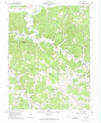
1961 Map of Byer
USGS Topo · Published 1974About this map
Wayne National Forest and the Richland Furnace State Forest dominate this early 1960s landscape, where industrial history and prehistoric sites meet. The Baltimore and Ohio railroad follows the winding path of Pigeon Creek, serving the small settlement of Byer (Byer June Sta) and the community at Ray. Near the village of Leo, the Leo Petroglyph State Memorial preserves ancient rock carvings on the edge of Washington township. For genealogists, the map is a dense record of family-named landmarks like Shoemaker Cem, Boblett Cem, and Harris Cem, alongside numerous strip mines that reveal the region's extraction economy. Further south, the map details the rural character of Savageville and Limerick, connected by a network of ridge-top roads and deep valleys like Buttermilk Hollow and Skunk Hollow.
Find a feature on this map
72 named features on this map. Tap any name to fly to it.
Don’t see what you’re looking for? This feature index may not catch every label — zoom into the map to look around manually.
Map Details
Editions of this 1961 Byer Map
4 editions found
Other maps of this area

1906 · Waverly
USGS Topo · 1:62,500

1906 · Chillicothe
USGS Topo · 1:62,500

1908 · Chillicothe
USGS Topo · 1:62,500

1908 · Waverly
USGS Topo · 1:62,500

1910 · Laurelville
USGS Topo · 1:62,500

1912 · Laurelville
USGS Topo · 1:62,500

1913 · Jackson
USGS Topo · 1:62,500

1944 · Jackson
USGS Topo · 1:62,500

1944 · Laurelville
USGS Topo · 1:62,500

1947 · Columbus
USGS Topo · 1:250,000