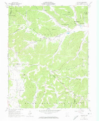
1961 Map of Byington
USGS Topo · Published 1974About this map
Kincaid Springs State Fish Hatchery and the neighboring hills of Pike State Forest anchor this early 1960s survey of southern Ohio's upland terrain. The landscape is defined by its deep hollows and narrow ridges, such as Hackle shin Ridge and Beekman Ridge, which dictate the placement of small settlements and family farmsteads. Small communities like Byington and Cedar Fork are situated along Sunfish Creek, while isolated crossroads such as Poplar Grove and Smoky Corners occupy the higher ground.
Find a feature on this map
62 named features on this map. Tap any name to fly to it.
Don’t see what you’re looking for? This feature index may not catch every label — zoom into the map to look around manually.
Map Details
Editions of this 1961 Byington Map
4 editions found
Other maps of this area

1915 · Bainbridge
USGS Topo · 1:48,000

1915 · Otway
USGS Topo · 1:62,500

1915 · Piketon
USGS Topo · 1:62,500

1916 · Peebles
USGS Topo · 1:62,500

1917 · Bainbridge
USGS Topo · 1:62,500

1917 · Piketon
USGS Topo · 1:62,500

1917 · Otway
USGS Topo · 1:62,500

1918 · Peebles
USGS Topo · 1:62,500

1944 · Piketon
USGS Topo · 1:62,500

1947 · Columbus
USGS Topo · 1:250,000