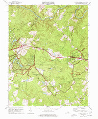
1973 Map of Chancellorsville
USGS Topo · Published 1974About this map
The Fredericksburg-Spotsylvania National Military Park dominates this 1973 revision, preserving the heavily wooded landscape of the Wilderness. The map meticulously records the intersection of military history and local geography, showing preserved Battle Trenches alongside markers like the Jackson Monument and Wadsworth Monument. Beyond the park boundaries, the industrial legacy of the region is evident at the Jackson Furnace and nearby Furnace Ruins along Lewis Run. Small crossroads communities like Wilderness Corner and Cookstown are charted alongside rural landmarks such as Wilderness Ch and Paynes Store. The Rapidan River forms the northern boundary, while the interior is etched with family-named terrain like Hamiltons Thicket and the path of the Old Grade Railroad.
Find a feature on this map
54 named features on this map. Tap any name to fly to it.
Don’t see what you’re looking for? This feature index may not catch every label — zoom into the map to look around manually.
Map Details
Editions of this 1973 Chancellorsville Map
3 editions found
Other maps of this area

1887 · Spottsylvania
USGS Topo · 1:125,000

1892 · Spottsylvania
USGS Topo · 1:125,000

1942 · Belmont
USGS Topo · 1:31,680

1942 · Spotsylania
USGS Topo · 1:31,680

1942 · Brokenburg
USGS Topo · 1:31,680

1943 · Germanna Bridge
USGS Topo · 1:24,000

1943 · Chancellorsville
USGS Topo · 1:24,000

1943 · Salem Church
USGS Topo · 1:24,000

1943 · Mine Run
USGS Topo · 1:24,000
1944 · Mine Run
USGS Topo · 1:31,680