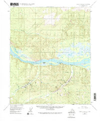
1956 Map of Charley River B-5
USGS Topo · Published 1975About this map
The Yukon River carves through the center of this 1950s interior landscape, serving as the primary corridor for transportation and settlement in a region defined by its waterway and mining prospects. Small cabins and outpost markers like the McGregor Cabin and Slaven Cabin dot the banks, while the presence of the Woodchopper Roadhouse (Aban'd) suggests the evolving nature of river travel and commerce.
Find a feature on this map
29 named features on this map. Tap any name to fly to it.
Don’t see what you’re looking for? This feature index may not catch every label — zoom into the map to look around manually.
Map Details
Editions of this 1956 Charley River B-5 Map
3 editions found
Other maps of this area

1951 · Charley River
USGS Topo · 1:250,000

1956 · Charley River C-5
USGS Topo · 1:63,360

1956 · Charley River C-6
USGS Topo · 1:63,360

1956 · Charley River B-6
USGS Topo · 1:63,360

1956 · Charley River A-5
USGS Topo · 1:63,360

1956 · Charley River A-4
USGS Topo · 1:63,360

1956 · Charley River B-5
USGS Topo · 1:63,360

1956 · Charley River A-6
USGS Topo · 1:63,360

1956 · Charley River C-4
USGS Topo · 1:63,360

1956 · Charley River B-4
USGS Topo · 1:63,360