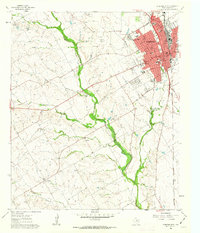
1961 Map of Cleburne West
USGS Topo · Published 1963About this map
The Gulf Colorado and Santa Fe (AT & SF) railroad serves as a corridor for growth in early 1960s Cleburne, centering much of the city's industry and infrastructure. Moving westward from the urban center of Cleburne, the landscape transitions into a network of small outlying settlements and school districts. Pockets of rural life are anchored by places like Lebanon, Robinson, and Burton, alongside numerous Gravel Pits and a Quarry that hint at the local mineral extraction and road-building needs of the era.
Find a feature on this map
48 named features on this map. Tap any name to fly to it.
Don’t see what you’re looking for? This feature index may not catch every label — zoom into the map to look around manually.
Map Details
Editions of this 1961 Cleburne West Map
3 editions found
Other maps of this area

1889 · Granbury
USGS Topo · 1:125,000

1891 · Cleburne
USGS Topo · 1:125,000

1894 · Cleburne
USGS Topo · 1:125,000

1924 · Cleburne 3-B
USGS Topo · 1:48,000

1924 · Granbury 4-a
USGS Topo · 1:48,000

1927 · Blum
USGS Topo · 1:62,500

1928 · Godley
USGS Topo · 1:62,500

1931 · Morgan
USGS Topo · 1:62,500

1954 · Dallas
USGS Topo · 1:250,000

1958 · Dallas
USGS Topo · 1:250,000