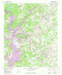
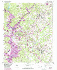
1951 Map of Clemson
USGS Topo · Published 1980About this map
Clemson University serves as a focal point for this Upstate landscape, where the confluence of the Seneca River and Keowee River forms the expansive Hartwell Lake. Originally surveyed in 1951, this edition includes purple revisions from 1977 that illustrate the rising waters of the reservoir and the expansion of Clemson and Pendleton. The map preserves the locations of numerous historic landmarks, such as the Old Stone Ch and the Treaty Oak Monument, alongside several rural schools including Abell Sch and New Hope Sch. To the north, the terrain rises toward Lake Issaqueena and the Issaqueena Lookout Tower, while the Southern railroad corridor connects the industrial and educational hubs of Central and Calhoun. The map documents a significant era of transition as hydroelectric development reshaped the river valleys.
Find a feature on this map
47 named features on this map. Tap any name to fly to it.
Don’t see what you’re looking for? This feature index may not catch every label — zoom into the map to look around manually.
Map Details
Editions of this 1951 Clemson Map
6 editions found
Other maps of this area

1888 · Pickens
USGS Topo · 1:125,000

1894 · Pickens
USGS Topo · 1:125,000

1950 · La France
USGS Topo · 1:24,000

1951 · La France
USGS Topo · 1:24,000

1951 · Clemson
USGS Topo · 1:24,000

1954 · Greenville
USGS Topo · 1:250,000

1957 · Anderson
USGS Topo · 1:62,500

1957 · Easley
USGS Topo · 1:62,500

1958 · Greenville
USGS Topo · 1:250,000

1958 · Seneca
USGS Topo · 1:24,000