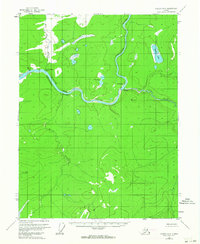
1956 Map of Coleen A-2
USGS Topo · Published 1964About this map
The Porcupine River carves a deep path through the Alaskan interior in this 1950s record of the Coleen region. This stretch of the river is defined by its sharp bends and the notable passage through the Canyon, where the water is flanked by landmarks like Howling Dog Rock. Human activity in this remote territory is centered along the riverbanks, evidenced by the presence of Old Rampart and Old Camp.
Find a feature on this map
10 named features on this map. Tap any name to fly to it.
Don’t see what you’re looking for? This feature index may not catch every label — zoom into the map to look around manually.
Map Details
Editions of this 1956 Coleen A-2 Map
3 editions found

Other maps of this area

1951 · Black River
USGS Topo · 1:250,000

1951 · Coleen
USGS Topo · 1:250,000

1956 · Coleen
USGS Topo · 1:250,000

1956 · Coleen B-2
USGS Topo · 1:63,360
1956 · Coleen B-1
USGS Topo · 1:63,360

1956 · Black River D-3
USGS Topo · 1:63,360

1956 · Coleen A-1
USGS Topo · 1:63,360

1956 · Coleen A-3
USGS Topo · 1:63,360

1956 · Black River D-2
USGS Topo · 1:63,360
1956 · Black River D-1
USGS Topo · 1:63,360