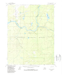
1956 Map of Coleen A-2
USGS Topo · Published 1988About this map
The Porcupine River snakes through this remote interior landscape, carving a deep Canyon as it flows toward the west. This mid-century survey captures the region as part of the Arctic National Wildlife Refuge, where the river network dictated human movement and settlement. Traces of early habitation are visible at Old Rampart and Old Camp along the riverbanks, likely serving as seasonal sites or trading points in this subarctic wilderness. The terrain is defined by distinctive landmarks like Howling Dog Rock and Red Gate, while the Salmon Trout River and Howling Dog Creek drain the surrounding uplands. Local hydrology is further marked by the Fern Lakes and Smith Lake, illustrating a complex web of waterways that supported the area's subsistence and transport long before modern infrastructure reached the Yukon-Koyukuk region.
Find a feature on this map
16 named features on this map. Tap any name to fly to it.
Don’t see what you’re looking for? This feature index may not catch every label — zoom into the map to look around manually.
Map Details
Editions of this 1956 Coleen A-2 Map
3 editions found

Other maps of this area

1951 · Black River
USGS Topo · 1:250,000

1951 · Coleen
USGS Topo · 1:250,000

1956 · Coleen
USGS Topo · 1:250,000

1956 · Coleen B-2
USGS Topo · 1:63,360
1956 · Coleen B-1
USGS Topo · 1:63,360

1956 · Black River D-3
USGS Topo · 1:63,360

1956 · Coleen A-1
USGS Topo · 1:63,360

1956 · Coleen A-3
USGS Topo · 1:63,360

1956 · Black River D-2
USGS Topo · 1:63,360
1956 · Black River D-1
USGS Topo · 1:63,360