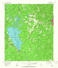
1955 Map of Curtis
USGS Topo · Published 1963About this map
Angelina National Forest dominates the northwestern landscape of this survey, where the Neches and Angelina rivers converge near the Dam B Reservoir. The map reveals a complex riverine environment defined by numerous sloughs and lakes, including Grass Pond Slough, Persimmon Pond Slough, and Jim Good Lake. This area was a focal point of early Texas history, evidenced by the Bevelport Townsite (Historical Monument) and the George Washington Smyth (Historical Monument) Cemetery.
Find a feature on this map
116 named features on this map. Tap any name to fly to it.
Don’t see what you’re looking for? This feature index may not catch every label — zoom into the map to look around manually.
Map Details
Editions of this 1955 Curtis Map
3 editions found
Other maps of this area

1931 · Zavalla
USGS Topo · 1:62,500

1952 · Lake Charles
USGS Topo · 1:250,000

1953 · Alexandria
USGS Topo · 1:250,000

1953 · Palestine
USGS Topo · 1:250,000

1954 · Lake Charles
USGS Topo · 1:250,000

1954 · Beaumont
USGS Topo · 1:250,000

1955 · Alexandria
USGS Topo · 1:250,000

1955 · Roganville
USGS Topo · 1:62,500

1955 · Woodville
USGS Topo · 1:62,500

1955 · Curtis
USGS Topo · 1:62,500