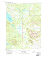
1954 Map of Dillingham B-7
USGS Topo · Published 1984About this map
Aleknagik serves as a focal point in this mid-century survey of the southwestern Alaskan interior. The landscape is defined by the massive Muklung Hills and the transition from the Wood-Tikchik State Park lowlands toward the higher elevations of Marsh Mountain. At the edge of the wilderness, a remote Mine and several scattered Cabin locations indicate small-scale human activity amidst a complex network of waterways, including the Wood River and the expansive Lake Nerka. Transport infrastructure at the time was limited to the water and air, evidenced by the presence of a Landing Strip and a Landing Area near Mosquito Point. The drainage patterns are intricate, with numerous streams such as Arcana Creek and the Muklung River winding through the basin, showing the natural state of the territory before modern development altered its character.
Find a feature on this map
20 named features on this map. Tap any name to fly to it.
Don’t see what you’re looking for? This feature index may not catch every label — zoom into the map to look around manually.
Map Details
Editions of this 1954 Dillingham B-7 Map
3 editions found
Other maps of this area

1951 · Dillingham
USGS Topo · 1:250,000

1952 · Dillingham A-8
USGS Topo · 1:63,360

1952 · Dillingham A-6
USGS Topo · 1:63,360

1952 · Dillingham A-7
USGS Topo · 1:63,360

1954 · Dillingham
USGS Topo · 1:250,000

1954 · Dillingham C-6
USGS Topo · 1:63,360

1954 · Dillingham B-7
USGS Topo · 1:63,360

1954 · Dillingham B-8
USGS Topo · 1:63,360

1954 · Dillingham B-6
USGS Topo · 1:63,360

1954 · Dillingham C-7
USGS Topo · 1:63,360