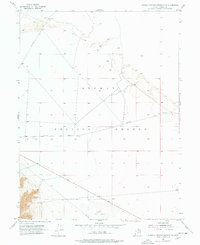
1954 Map of Dugway Proving Ground NW
USGS Topo · Published 1978About this map
Dugway Proving Ground dominates this 1954 topographic study of the Tooele County desert, a landscape shaped by military activity and sparse infrastructure. The map details a network of functional transit routes that crisscross the arid flats, including Falconer Road in the northwest, Stark Road in the southwest, and the long stretch of Goodyear Road. These tracks provide access across an otherwise featureless terrain, occasionally marked by survey markers such as Gpi-3 and a series of bench marks like Bm 4301 and Bm 4297. To the south, the basin is defined by the wide expanse of Dry Lake, a seasonal feature typical of the Great Salt Lake Desert. The precise recording of elevation points and these isolated roads offers a clear view of the area's geography shortly after its establishment as a primary military testing site.
Find a feature on this map
11 named features on this map. Tap any name to fly to it.
Don’t see what you’re looking for? This feature index may not catch every label — zoom into the map to look around manually.
Map Details
Editions of this 1954 Dugway Proving Ground NW Map
4 editions found
Other maps of this area

1953 · Tooele
USGS Topo · 1:250,000

1954 · Wig Mtn SW
USGS Topo · 1:24,000

1954 · Dugway Proving Ground SE
USGS Topo · 1:24,000

1954 · Dugway Proving Ground NE
USGS Topo · 1:24,000

1954 · Granite Peak
USGS Topo · 1:24,000

1954 · Dugway Proving Ground SW
USGS Topo · 1:24,000

1954 · Wildcat Mtn SE
USGS Topo · 1:24,000

1954 · Dugway Proving Ground NW
USGS Topo · 1:24,000

1954 · Granite Peak SE
USGS Topo · 1:24,000

1955 · Wig Mtn
USGS Topo · 1:24,000