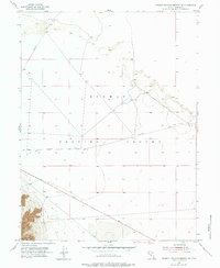
1954 Map of Dugway Proving Ground NW
USGS Topo · Published 1984About this map
The Dugway Proving Ground dominates this 1954 topographic record, illustrating the remote and specialized nature of this Tooele County military landscape during the early Cold War. The terrain is characterized by expansive flatlands and intermittent drainage patterns, notably the large Dry Lake feature in the southern portion of the quadrangle. Transportation across this restricted territory is limited to a sparse network of designated routes, including Goodyear Road, Stark Road, and Falconer Road. The map provides a clear look at the surveying and infrastructural layout of the proving grounds before subsequent decades of development, capturing the stark, functional geometry of military land management in the Utah desert.
Find a feature on this map
5 named features on this map. Tap any name to fly to it.
Don’t see what you’re looking for? This feature index may not catch every label — zoom into the map to look around manually.
Map Details
Editions of this 1954 Dugway Proving Ground NW Map
4 editions found
Other maps of this area

1953 · Tooele
USGS Topo · 1:250,000

1954 · Wig Mtn SW
USGS Topo · 1:24,000

1954 · Dugway Proving Ground SE
USGS Topo · 1:24,000

1954 · Dugway Proving Ground NE
USGS Topo · 1:24,000

1954 · Granite Peak
USGS Topo · 1:24,000

1954 · Dugway Proving Ground SW
USGS Topo · 1:24,000

1954 · Wildcat Mtn SE
USGS Topo · 1:24,000

1954 · Dugway Proving Ground NW
USGS Topo · 1:24,000

1954 · Granite Peak SE
USGS Topo · 1:24,000

1955 · Wig Mtn
USGS Topo · 1:24,000