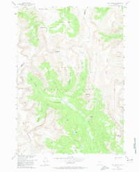
1956 Map of Five Pockets
USGS Topo · Published 1974About this map
Shoshone National Forest defines the high-altitude landscape of this mid-century survey, specifically the area surrounding the intricate drainage system of the Five Pockets. The map details a primitive network of routes, including a Jeep Trail and several stretches of Pack Trail, emphasizing the area's isolation and reliance on traditional mountain transit during the 1950s. Geologic features dominate the terrain, from the sharp relief of Cathedral Peak and Raggedtop Mountain to the specialized glacial-carved bowls like South Pocket and Hidden Pocket. The mapping of small alpine water bodies such as Eloise Lake and Deacon Lake, along with the steep descent of Twilight Falls, provides essential landmarks for historical backcountry research. This survey was conducted as part of the Department of the Interior program for the development of the Missouri River Basin, capturing the character of the Park and Fremont county border before modern infrastructure changes.
Find a feature on this map
31 named features on this map. Tap any name to fly to it.
Don’t see what you’re looking for? This feature index may not catch every label — zoom into the map to look around manually.
Map Details
Editions of this 1956 Five Pockets Map
3 editions found
Other maps of this area

1905 · Younts Peak
USGS Topo · 1:125,000

1907 · Younts Peak
USGS Topo · 1:125,000

1955 · Thermopolis
USGS Topo · 1:250,000

1956 · Indian Point
USGS Topo · 1:24,000

1956 · Esmond Park
USGS Topo · 1:24,000

1956 · Shoshone Pass
USGS Topo · 1:24,000

1956 · Ramshorn Peak
USGS Topo · 1:24,000

1956 · Snow Lake
USGS Topo · 1:24,000

1956 · Five Pockets
USGS Topo · 1:24,000

1956 · Emerald Lake
USGS Topo · 1:24,000