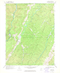
1968 Map of Glady
USGS Topo · Published 1971About this map
Glady Fork and Laurel Fork cut deep north-south valleys through this high-altitude section of the Monongahela National Forest. The settlement of Glady sits along the Western Maryland railroad line, which follows the twisting course of the West Fork and passes through the smaller community of Bemis to the northwest. This 1968 field-checked record captures a landscape of resource extraction and rugged infrastructure, indicated by scattered mines, a Strip Mine, and a Compressor Station along a network of pipelines. The terrain is defined by massive ridges, including Shavers Mountain and Rich Mountain, while several jeep trails provide the only access to the high ground. Local history is preserved in family-named landmarks such as Frazier Ridge and McCray Creek, alongside a small Cem near the valley floor, showing the sparse but persistent human footprint in these mountains.
Find a feature on this map
55 named features on this map. Tap any name to fly to it.
Don’t see what you’re looking for? This feature index may not catch every label — zoom into the map to look around manually.
Map Details
Editions of this 1968 Glady Map
2 editions found
Other maps of this area

1889 · Beverly
USGS Topo · 1:125,000

1892 · Beverly
USGS Topo · 1:125,000

1909 · Elkins
USGS Topo · 1:62,500

1922 · Horton
USGS Topo · 1:48,000

1922 · Spruce Knob
USGS Topo · 1:48,000

1922 · Durbin
USGS Topo · 1:48,000

1924 · Durbin
USGS Topo · 1:62,500

1924 · Horton
USGS Topo · 1:62,500

1924 · Spruce Knob
USGS Topo · 1:62,500

1949 · Charlottesville
USGS Topo · 1:250,000