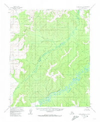
1955 Map of Kateel River C-5
USGS Topo · Published 1974About this map
The Continental Divide cuts through the northwestern corner of this 1955 survey, marking the high ground of the Interior Alaska wilderness. This terrain is defined by the winding course of the Huslia River and its South Fork, which meander through a landscape of intricate drainage patterns and low-lying marshes. The southern portion of the sheet is dominated by the Kateel River, flowing eastward through unsurveyed lands predetermined by the Bureau of Land Management.
Find a feature on this map
7 named features on this map. Tap any name to fly to it.
Don’t see what you’re looking for? This feature index may not catch every label — zoom into the map to look around manually.
Map Details
Editions of this 1955 Kateel River C-5 Map
3 editions found
Other maps of this area

1951 · Kateel River
USGS Topo · 1:250,000

1952 · Kateel River B-4
USGS Topo · 1:63,360

1954 · Kateel River C-4
USGS Topo · 1:63,360

1954 · Kateel River D-4
USGS Topo · 1:63,360

1954 · Kateel River B-5
USGS Topo · 1:63,360

1954 · Kateel River D-6
USGS Topo · 1:63,360

1954 · Kateel River D-5
USGS Topo · 1:63,360

1954 · Kateel River C-6
USGS Topo · 1:63,360

1955 · Kateel River B-5
USGS Topo · 1:63,360
1955 · Kateel River B-6
USGS Topo · 1:63,360