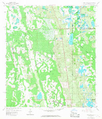
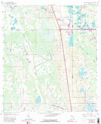
1959 Map of Lake Louisa SW
USGS Topo · Published 1968About this map
The Green Swamp dominates this Central Florida landscape at the end of the 1950s, revealing a complex hydrological network where Lake, Polk, Orange, and Osceola counties meet. The interior is largely defined by slow-moving water and isolated hammocks like Oak Island and Fishers Island, positioned east of the expansive Davenport Creek Swamp. Transportation through this marshy terrain is sparse, relying on the Old Tram Road in the north and Dean Still Road to the south. Small water bodies, including Lake Davenport, Hancock Lake, and Lake Austin, are interconnected by seasonal flows such as Big Creek and Green Swamp Run. The map illustrates the region before significant drainage or modernization altered these wetlands, with an industrial pipeline and a few rural thoroughfares like Loughman Road representing the only major human infrastructure in this vast hydrographic basin.
Find a feature on this map
31 named features on this map. Tap any name to fly to it.
Don’t see what you’re looking for? This feature index may not catch every label — zoom into the map to look around manually.
Map Details
Editions of this 1959 Lake Louisa SW Map
7 editions found


Other maps of this area

1944 · Polk City
USGS Topo · 1:31,680

1953 · Windermere
USGS Topo · 1:24,000

1953 · Intercession City
USGS Topo · 1:24,000

1953 · Davenport
USGS Topo · 1:24,000

1955 · Orlando
USGS Topo · 1:250,000

1957 · Orlando
USGS Topo · 1:250,000

1958 · Orlando
USGS Topo · 1:250,000

1959 · Gum Lake
USGS Topo · 1:24,000

1959 · Lake Nellie
USGS Topo · 1:24,000

1959 · Lake Louisa
USGS Topo · 1:24,000