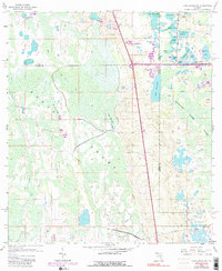
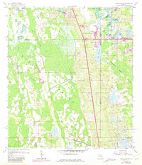
1959 Map of Lake Louisa SW
USGS Topo · Published 1991About this map
The Green Swamp dominates this landscape, showing the complex hydrology of central Florida before modern development reshaped much of the region. As documented in this late 1950s survey, the area is a mosaic of cypress strands and wetlands, drained by Big Creek and Green Swamp Run. Notable terrain features like Oak Island and Fishers Island rise above the Davenport Creek Swamp, offering insights into the natural islands that once provided dry ground in an otherwise saturated environment.
Find a feature on this map
32 named features on this map. Tap any name to fly to it.
Don’t see what you’re looking for? This feature index may not catch every label — zoom into the map to look around manually.
Map Details
Editions of this 1959 Lake Louisa SW Map
7 editions found


Other maps of this area

1944 · Polk City
USGS Topo · 1:31,680

1953 · Windermere
USGS Topo · 1:24,000

1953 · Intercession City
USGS Topo · 1:24,000

1953 · Davenport
USGS Topo · 1:24,000

1955 · Orlando
USGS Topo · 1:250,000

1957 · Orlando
USGS Topo · 1:250,000

1958 · Orlando
USGS Topo · 1:250,000

1959 · Gum Lake
USGS Topo · 1:24,000

1959 · Lake Nellie
USGS Topo · 1:24,000

1959 · Lake Louisa
USGS Topo · 1:24,000