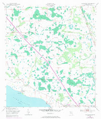
1953 Map of Lake Marian NE
USGS Topo · Published 1984About this map
Lake Marian anchors the southern edge of this landscape, which in the early 1950s was characterized by a complex network of wetlands and cattle ranching. The map illustrates a period of transition, showing the infrastructure of the Floridas Turnpike Toll cutting diagonally across the terrain, superimposed over older landscape markers like the Old Railroad Grade. This intersection of modern transit and historical rail routes highlights the evolution of Osceola County’s interior.
Find a feature on this map
26 named features on this map. Tap any name to fly to it.
Don’t see what you’re looking for? This feature index may not catch every label — zoom into the map to look around manually.
Map Details
Editions of this 1953 Lake Marian NE Map
5 editions found
Other maps of this area

1953 · Lake Marian NW
USGS Topo · 1:24,000

1953 · Lake Marian SE
USGS Topo · 1:24,000

1953 · Holopaw SE
USGS Topo · 1:24,000

1953 · Kenansville SW
USGS Topo · 1:24,000

1953 · Lake Marian SW
USGS Topo · 1:24,000

1953 · Kenansville
USGS Topo · 1:24,000

1953 · Holopaw SW
USGS Topo · 1:24,000

1953 · Deer Park
USGS Topo · 1:24,000

1953 · Lake Marian NE
USGS Topo · 1:24,000

1955 · Orlando
USGS Topo · 1:250,000