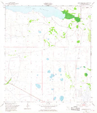
1953 Map of Lake Marian SE
USGS Topo · Published 1968About this map
Lake Marian defines the northern edge of this Osceola County landscape, where the shoreline meets a network of wetlands and scattered ponds at an elevation of 59 feet. The small settlement of Whittier appears in the northeast corner, serving as a primary point of human activity near a local cemetery. This 1950s survey reflects a period when the Florida interior remained largely undeveloped, characterized by wide-open spaces and essential resource management infrastructure. The terrain is marked by hydrological features like Blanket Bay Slough and technical installations including a gaging station and a windmill. Grounded in field checks by the Geological Survey, the map also traces the Peavine Trail as it cuts through the southeastern quadrant, providing a vital path through the marshy lowland environment.
Find a feature on this map
10 named features on this map. Tap any name to fly to it.
Don’t see what you’re looking for? This feature index may not catch every label — zoom into the map to look around manually.
Map Details
Editions of this 1953 Lake Marian SE Map
4 editions found
Other maps of this area

1952 · Fort Kissimmee NW
USGS Topo · 1:24,000

1953 · Lake Marian NW
USGS Topo · 1:24,000

1953 · Fort Kissimmee NE
USGS Topo · 1:24,000

1953 · Lake Marian SE
USGS Topo · 1:24,000

1953 · Fort Drum NW
USGS Topo · 1:24,000

1953 · Kenansville SW
USGS Topo · 1:24,000

1953 · Lake Marian SW
USGS Topo · 1:24,000

1953 · Kenansville
USGS Topo · 1:24,000

1953 · Lake Marian NE
USGS Topo · 1:24,000

1956 · Fort Pierce
USGS Topo · 1:250,000