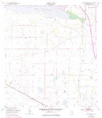
1953 Map of Lake Marian SE
USGS Topo · Published 1984About this map
Lake Marian anchors the northern landscape of this interior Florida region, where the shoreline transitions into the residential development of Lake Marian Highlands. Further east, the small settlement of Whittier sits near the edge of the wetlands, providing a glimpse into the localized geography of Osceola County during the mid-20th century. The transportation network is defined by the high-speed transit of the Floridas Turnpike Toll Road, which contrasts with the older, more utilitarian Peavine Trail cutting through the open terrain.
Find a feature on this map
10 named features on this map. Tap any name to fly to it.
Don’t see what you’re looking for? This feature index may not catch every label — zoom into the map to look around manually.
Map Details
Editions of this 1953 Lake Marian SE Map
4 editions found
Other maps of this area

1952 · Fort Kissimmee NW
USGS Topo · 1:24,000

1953 · Lake Marian NW
USGS Topo · 1:24,000

1953 · Fort Kissimmee NE
USGS Topo · 1:24,000

1953 · Lake Marian SE
USGS Topo · 1:24,000

1953 · Fort Drum NW
USGS Topo · 1:24,000

1953 · Kenansville SW
USGS Topo · 1:24,000

1953 · Lake Marian SW
USGS Topo · 1:24,000

1953 · Kenansville
USGS Topo · 1:24,000

1953 · Lake Marian NE
USGS Topo · 1:24,000

1956 · Fort Pierce
USGS Topo · 1:250,000