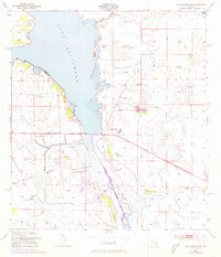
1953 Map of Lake Marian SW
USGS Topo · Published 1973About this map
Lake Kissimmee and the meandering headwaters of the Kissimmee River dominate this interior Florida landscape, recorded by the U.S. Corps of Engineers in the early 1950s. The terrain is defined by a network of drainage ways including Buttermilk Slough, Packingham Slough, and the curiously named Ice Cream Slough. This survey captures the region's hydrography and topography before significant modern alterations, showing the natural interaction between the river and the surrounding wetlands. Scattered throughout the grassy lowlands are distinct elevated areas known locally as hammocks, including Ute Hammock, Turkey Hammock, and Wildcat Hammock, which often served as key landmarks and habitable ground in the wet prairie. Large landforms like Brahma Island stand out within the lake, while a Pumping Station along the western shore indicates early efforts to manage the local water levels for agriculture or ranching.
Find a feature on this map
19 named features on this map. Tap any name to fly to it.
Don’t see what you’re looking for? This feature index may not catch every label — zoom into the map to look around manually.
Map Details
Editions of this 1953 Lake Marian SW Map
3 editions found
Other maps of this area

1952 · Lake Weohyakapka SE
USGS Topo · 1:24,000

1952 · Lake Weohyakapka NE
USGS Topo · 1:24,000

1952 · Fort Kissimmee NW
USGS Topo · 1:24,000

1952 · Lake Arbuckle NE
USGS Topo · 1:24,000

1953 · Lake Marian NW
USGS Topo · 1:24,000

1953 · Fort Kissimmee NE
USGS Topo · 1:24,000

1953 · Lake Marian SE
USGS Topo · 1:24,000

1953 · Lake Marian SW
USGS Topo · 1:24,000

1953 · Lake Marian NE
USGS Topo · 1:24,000

1956 · Fort Pierce
USGS Topo · 1:250,000