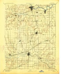
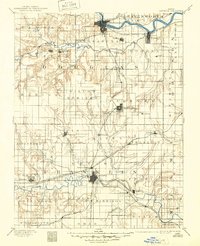
1889 Map of Lawrence
USGS Topo · Published 1913About this map
The Kansas River and Marais Des Cygnes River systems anchor this late 19th-century landscape, illustrating the early settlement patterns of eastern Kansas. Lawrence sits at the northern rail junction of the Union Pacific Railroad and the Atchison Topeka and Santa Fe Railroad, while Ottawa serves as a southern hub for the Southern Kansas Railroad and the Missouri Pacific Railroad. Beyond these central towns, the map documents a network of smaller communities such as Vinland, Sibley, and Centropolis. Prominent terrain markers like Blue Mound and the Three Sisters provide navigational landmarks amidst the intricate drainage of Wakarusa Creek and Eight Mile Creek. The division of the territory into townships like Palmyra and Kanwaka reflects the formal organization of the frontier as it moved toward a more established agricultural and industrial economy.
Find a feature on this map
82 named features on this map. Tap any name to fly to it.
Don’t see what you’re looking for? This feature index may not catch every label — zoom into the map to look around manually.
Map Details
Editions of this 1889 Lawrence Map
6 editions found
Other maps of this area

1885 · Burlington
USGS Topo · 1:125,000

1885 · Garnett
USGS Topo · 1:125,000

1885 · Lawrence
USGS Topo · 1:125,000

1886 · Oskaloosa
USGS Topo · 1:125,000

1887 · Olathe
USGS Topo · 1:125,000

1887 · Mound City
USGS Topo · 1:125,000

1888 · Oskaloosa
USGS Topo · 1:125,000

1889 · Burlingame
USGS Topo · 1:125,000

1889 · Topeka
USGS Topo · 1:125,000

1889 · Lawrence
USGS Topo · 1:125,000