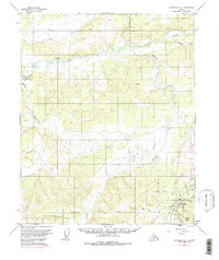
1952 Map of Livengood C-4
USGS Topo · Published 1977About this map
Livengood and the surrounding gold-bearing creeks define this interior Alaska landscape during a period of transition between traditional mining and large-scale infrastructure projects. The settlement is centered near the junction of Myrtle Creek and Ruth Creek, where extensive Tailings indicate the area's placer mining legacy. The presence of the Livengood Aqueduct and various water systems like the one at Erickson highlight the complex engineering required to support operations in this subarctic environment.
Find a feature on this map
22 named features on this map. Tap any name to fly to it.
Don’t see what you’re looking for? This feature index may not catch every label — zoom into the map to look around manually.
Map Details
Editions of this 1952 Livengood C-4 Map
4 editions found
Other maps of this area

1945 · Livengood
USGS Topo · 1:250,000

1951 · Livengood
USGS Topo · 1:250,000

1951 · Livengood D-3
USGS Topo · 1:63,360

1952 · Livengood C-5
USGS Topo · 1:63,360

1952 · Livengood B-5
USGS Topo · 1:63,360

1952 · Livengood D-5
USGS Topo · 1:63,360

1952 · Livengood C-4
USGS Topo · 1:63,360

1953 · Livengood B-4
USGS Topo · 1:63,360

1953 · Livengood D-4
USGS Topo · 1:63,360

1954 · Livengood B-3
USGS Topo · 1:63,360