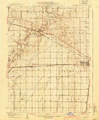
1907 Map of Mahomet
USGS Topo · Published 1940About this map
Mahomet and the surrounding central Illinois prairies are documented here based on surveys from the early 1900s. The landscape is defined by the winding course of the Sangamon River and a strictly ordered grid of township boundaries including Newcomb, Mahomet, and Hensley. This map illustrates a transition era in rural education and transport, with numerous one-room schoolhouses like Hannah School and South Prairie School dotting the sections between established railroad stops. The Cleveland Cincinnati Chicago and St Louis line cuts diagonally toward Rising, while the Illinois Central serves the eastern edge of the quadrangle near the growing center of Champaign. Local landmarks such as the prominent Blue Mound and the headwaters of the Kaskaskia River provide geographic anchors for a region defined by its productive farmland and developing rail-and-river network.
Find a feature on this map
35 named features on this map. Tap any name to fly to it.
Don’t see what you’re looking for? This feature index may not catch every label — zoom into the map to look around manually.
Map Details
Editions of this 1907 Mahomet Map
5 editions found
Other maps of this area

1906 · Urbana
USGS Topo · 1:62,500

1907 · Mahomet
USGS Topo · 1:62,500

1924 · Paxton
USGS Topo · 1:62,500

1927 · Paxton
USGS Topo · 1:62,500

1928 · Gibson City
USGS Topo · 1:62,500

1937 · Monticello
USGS Topo · 1:48,000

1943 · Monticello
USGS Topo · 1:62,500

1949 · Paxton
USGS Topo · 1:62,500

1950 · Tuscola
USGS Topo · 1:62,500

1952 · Arrowsmith
USGS Topo · 1:62,500