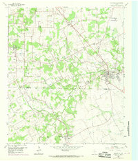
1959 Map of Mansfield
USGS Topo · Published 1969About this map
The Southern Pacific and Missouri Pacific railroad corridors anchor this North Texas landscape, converging toward the growing community of Mansfield. This late 1950s survey captures a rural environment in transition, where scattered settlements like Rendon, Retta, and Lillian are connected by a network of farm roads and drainage systems including Walnut Creek and Hogpen Branch. The map provides significant genealogical value, documenting numerous rural institutions such as the Rendon Ch, New Hope Ch, and Pleasant Point Ch. Local education history is preserved through the locations of the Bludworth Sch and Nash Sch, while the agricultural and industrial character is reflected in the numerous Gravel Pits and a specialized Fish Hatchery. Notable burial grounds, including Hudson Cem and Grimsley Cem, remain as landmarks of the area's early family settlements.
Find a feature on this map
38 named features on this map. Tap any name to fly to it.
Don’t see what you’re looking for? This feature index may not catch every label — zoom into the map to look around manually.
Map Details
Editions of this 1959 Mansfield Map
5 editions found

Other maps of this area

1891 · Cleburne
USGS Topo · 1:125,000

1894 · Cleburne
USGS Topo · 1:125,000

1894 · Fort Worth
USGS Topo · 1:125,000

1954 · Dallas
USGS Topo · 1:250,000

1955 · Burleson
USGS Topo · 1:24,000

1955 · Fort Worth
USGS Topo · 1:24,000

1958 · Dallas
USGS Topo · 1:250,000

1959 · Kennedale
USGS Topo · 1:24,000

1959 · Arlington
USGS Topo · 1:24,000

1959 · Britton
USGS Topo · 1:24,000