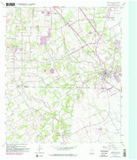
1959 Map of Mansfield
USGS Topo · Published 1982About this map
Mansfield serves as the focal point of this North Texas survey, positioned along the Southern Pacific rail line at the crossroads of Tarrant and Johnson counties. The landscape transitions from the early suburban growth of Arlington in the north to established rural communities like Lillian, Retta, and Rendon to the south and west. Local landmarks such as Nash Sch, Bludworth Sch, and the Powerhouse Ch anchor these small settlements, reflecting the mid-century social infrastructure of the region.
Find a feature on this map
45 named features on this map. Tap any name to fly to it.
Don’t see what you’re looking for? This feature index may not catch every label — zoom into the map to look around manually.
Map Details
Editions of this 1959 Mansfield Map
5 editions found

Other maps of this area

1891 · Cleburne
USGS Topo · 1:125,000

1894 · Cleburne
USGS Topo · 1:125,000

1894 · Fort Worth
USGS Topo · 1:125,000

1954 · Dallas
USGS Topo · 1:250,000

1955 · Burleson
USGS Topo · 1:24,000

1955 · Fort Worth
USGS Topo · 1:24,000

1958 · Dallas
USGS Topo · 1:250,000

1959 · Kennedale
USGS Topo · 1:24,000

1959 · Arlington
USGS Topo · 1:24,000

1959 · Britton
USGS Topo · 1:24,000