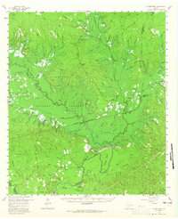
1958 Map of Mc Gee Bend
USGS Topo · Published 1965About this map
Mc Gee Bend Dam serves as the focal point of this late 1950s survey, capturing the landscape just before the creation of the Sam Rayburn Reservoir. The map illustrates the planned inundation areas of the Angelina River valley with blue hatching, marking the imminent transformation of the Angelina National Forest. For genealogists, the map is a vital record of deep East Texas history, documenting dozens of family burial grounds such as Oak Grove Cem, Mc Gee Hill Cem, and the Mill Graves.
Find a feature on this map
107 named features on this map. Tap any name to fly to it.
Don’t see what you’re looking for? This feature index may not catch every label — zoom into the map to look around manually.
Map Details
Editions of this 1958 Mc Gee Bend Map

Other maps of this area

1931 · Zavalla
USGS Topo · 1:62,500

1952 · Lake Charles
USGS Topo · 1:250,000

1953 · Alexandria
USGS Topo · 1:250,000

1953 · Palestine
USGS Topo · 1:250,000

1954 · Lake Charles
USGS Topo · 1:250,000

1954 · Beaumont
USGS Topo · 1:250,000

1955 · Alexandria
USGS Topo · 1:250,000

1955 · Roganville
USGS Topo · 1:62,500

1955 · Woodville
USGS Topo · 1:62,500

1955 · Curtis
USGS Topo · 1:62,500