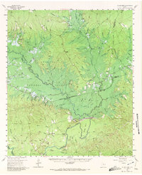
1958 Map of Mc Gee Bend
USGS Topo · Published 1972About this map
The Angelina River winds through this 1958 landscape shortly before the completion of the Dam (Under Construction) that would eventually create the Sam Rayburn Reservoir. This transitional era is frozen on paper, showing the valley floor before inundation, with the Angelina National Forest covering much of the terrain. The map serves as a vital record for genealogists, identifying numerous family burial grounds such as Williams Cemetery, Parker Cemetery, and Hensarling Cemetery.
Find a feature on this map
114 named features on this map. Tap any name to fly to it.
Don’t see what you’re looking for? This feature index may not catch every label — zoom into the map to look around manually.
Map Details
Editions of this 1958 Mc Gee Bend Map

Other maps of this area

1931 · Zavalla
USGS Topo · 1:62,500

1952 · Lake Charles
USGS Topo · 1:250,000

1953 · Alexandria
USGS Topo · 1:250,000

1953 · Palestine
USGS Topo · 1:250,000

1954 · Lake Charles
USGS Topo · 1:250,000

1954 · Beaumont
USGS Topo · 1:250,000

1955 · Alexandria
USGS Topo · 1:250,000

1955 · Roganville
USGS Topo · 1:62,500

1955 · Woodville
USGS Topo · 1:62,500

1955 · Curtis
USGS Topo · 1:62,500