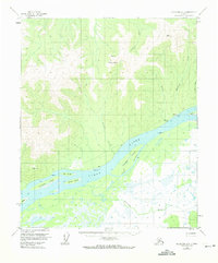
1953 Map of Melozitna A-2
USGS Topo · Published 1974About this map
The Yukon River dominates this interior Alaska landscape, carving a wide path through the territory just north of the Klatsuta River. In the early 1950s, human activity was concentrated along the riverbanks, where a Native Fishing Camp and scattered Cabins were positioned to take advantage of the seasonal fish runs. The small settlement at Birches is served by a Landing Strip, reflecting the critical role of bush aviation in connecting these remote riverine communities. North of the main channel, the terrain rises toward Gold Mountain, while the river itself is fragmented by a complex network of braids and islands. Major landmasses within the flow include Lady Island, Chokoyik Island, and Youngs Island, many of which are separated from the northern bank by Pike Slough. The intricate drainage patterns of Hudson Creek, Montana Creek, and Birches Creek show the varied relief of the uplands before they descend into the marshy lowlands of the Yukon valley.
Find a feature on this map
23 named features on this map. Tap any name to fly to it.
Don’t see what you’re looking for? This feature index may not catch every label — zoom into the map to look around manually.
Map Details
Editions of this 1953 Melozitna A-2 Map
2 editions found
Other maps of this area

1951 · Ruby
USGS Topo · 1:250,000

1951 · Melozitna
USGS Topo · 1:250,000

1952 · Melozitna A-2
USGS Topo · 1:63,360

1952 · Ruby D-1
USGS Topo · 1:63,360

1952 · Ruby D-3
USGS Topo · 1:63,360

1952 · Ruby D-2
USGS Topo · 1:63,360

1952 · Ruby
USGS Topo · 1:250,000

1952 · Melozitna A-1
USGS Topo · 1:63,360

1953 · Melozitna A-2
USGS Topo · 1:63,360

1954 · Melozitna B-3
USGS Topo · 1:63,360