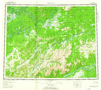
1956 Map of Melozitna
USGS Topo · Published 1961About this map
The Yukon River and Koyukuk River dominate this mid-century interior landscape, carving through the Kokrines Hills and Isanotski Mountains. The map documents a period of subsistence and communication infrastructure, showing the Telegraph Line cutting through the wilderness alongside traditional seasonal sites like Twelvemile Fishing Camp and Birches Native Fishing Camp. The hydrography is particularly intricate, with the Dulbi River, Melozitna River, and Little Indian River feeding into the larger systems, dotted by numerous river islands including Treat Island and Cronin Island.
Find a feature on this map
70 named features on this map. Tap any name to fly to it.
Don’t see what you’re looking for? This feature index may not catch every label — zoom into the map to look around manually.
Map Details
Editions of this 1956 Melozitna Map
5 editions found

Other maps of this area

1945 · Nulato
USGS Topo · 1:250,000

1948 · Kantishna River
USGS Topo · 1:250,000

1951 · Shungnak
USGS Topo · 1:250,000

1951 · Nulato
USGS Topo · 1:250,000

1951 · Kantishna River
USGS Topo · 1:250,000

1951 · Ruby
USGS Topo · 1:250,000

1951 · Kateel River
USGS Topo · 1:250,000

1951 · Hughes
USGS Topo · 1:250,000

1951 · Melozitna
USGS Topo · 1:250,000

1951 · Bettles
USGS Topo · 1:250,000