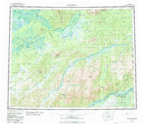
1956 Map of Melozitna
USGS Topo · Published 1984About this map
The Koyukuk River and Yukon River dominate this interior landscape, defining a region of seasonal camps and vast wetlands. Settled life in this mid-century period is largely represented by river-access points and remote outposts, including Twelvemile Fishing Camp and Birches Native Fishing Camp. Geothermal activity is a notable characteristic of the terrain, with several thermal features such as Pocahontas Hot Springs and Melozitna Springs appearing near the mountain foothills. The map provides a clear look at the early infrastructure of the Koyukuk National Wildlife Refuge, where geographic landmarks like Hochandochtla Mountain and the Takakhdona Hills rise above the meandering sloughs. Farther south, the Nowitna National Wildlife Refuge borders the Yukon, where various islands such as Cronin Island and Weir Island shift with the river's flow.
Find a feature on this map
92 named features on this map. Tap any name to fly to it.
Don’t see what you’re looking for? This feature index may not catch every label — zoom into the map to look around manually.
Map Details
Editions of this 1956 Melozitna Map
5 editions found

Other maps of this area

1945 · Nulato
USGS Topo · 1:250,000

1948 · Kantishna River
USGS Topo · 1:250,000

1951 · Shungnak
USGS Topo · 1:250,000

1951 · Nulato
USGS Topo · 1:250,000

1951 · Kantishna River
USGS Topo · 1:250,000

1951 · Ruby
USGS Topo · 1:250,000

1951 · Kateel River
USGS Topo · 1:250,000

1951 · Hughes
USGS Topo · 1:250,000

1951 · Melozitna
USGS Topo · 1:250,000

1951 · Bettles
USGS Topo · 1:250,000