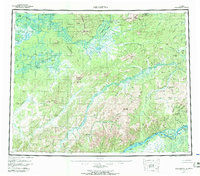
1956 Map of Melozitna
USGS Topo · Published 1971About this map
Koyukuk River and Melozitna River dominate this interior landscape, where mid-century life followed the seasonal flow of water and terrain. The map records a series of essential bush outposts and camps, from Twelvemile Fishing Camp and Birches Native Fishing Camp to the isolated Twentyfive Mile Cabin. Several geothermal features, including Melozitna Hot Springs, Pocahontas Hot Springs, and Little Melozitna Hot Springs, provide notable landmarks in the Isahultila Mountains and surrounding hills. These sites, often located near river bends or sloughs like Pocahontas Slough, were critical nodes for navigation and survival before modern infrastructure reached this part of the Yukon-Koyukuk region. Evidence of changing land use is visible at the Reindeer Camp (Aband) near Hot Springs Creek, marking a transition from historical herding practices to a more transient pattern of cabins and fishing sites.
Find a feature on this map
100 named features on this map. Tap any name to fly to it.
Don’t see what you’re looking for? This feature index may not catch every label — zoom into the map to look around manually.
Map Details
Editions of this 1956 Melozitna Map
5 editions found

Other maps of this area

1945 · Nulato
USGS Topo · 1:250,000

1948 · Kantishna River
USGS Topo · 1:250,000

1951 · Shungnak
USGS Topo · 1:250,000

1951 · Nulato
USGS Topo · 1:250,000

1951 · Kantishna River
USGS Topo · 1:250,000

1951 · Ruby
USGS Topo · 1:250,000

1951 · Kateel River
USGS Topo · 1:250,000

1951 · Hughes
USGS Topo · 1:250,000

1951 · Melozitna
USGS Topo · 1:250,000

1951 · Bettles
USGS Topo · 1:250,000