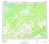
1956 Map of Melozitna
USGS Topo · Published 1978About this map
The Koyukuk River and Yukon River define the life and travel of this Interior Alaska landscape during the mid-1950s. Traditional subsistence and fishing sites are well-documented, including the Birches Native Fishing Camp and Twelvemile Fishing Camp, alongside the Melozitna Native Village. These sites, connected by a Telegraph Line following the Yukon, represent the intersection of ancestral lands with mid-century communication infrastructure. Geothermal features like Pocahontas Hot Springs and Melozitna Hot Springs highlight the unique geology of the Indian Mts and Kokrines hills. Small-scale resource extraction is visible through the Macer Mine and Placer Mine near the riverbanks. The prevalence of seasonal dwellings such as Eightmile Cabins and the Reindeer Camp reflects a landscape utilized for hunting and trapping far from established town centers.
Find a feature on this map
99 named features on this map. Tap any name to fly to it.
Don’t see what you’re looking for? This feature index may not catch every label — zoom into the map to look around manually.
Map Details
Editions of this 1956 Melozitna Map
5 editions found

Other maps of this area

1945 · Nulato
USGS Topo · 1:250,000

1948 · Kantishna River
USGS Topo · 1:250,000

1951 · Shungnak
USGS Topo · 1:250,000

1951 · Nulato
USGS Topo · 1:250,000

1951 · Kantishna River
USGS Topo · 1:250,000

1951 · Ruby
USGS Topo · 1:250,000

1951 · Kateel River
USGS Topo · 1:250,000

1951 · Hughes
USGS Topo · 1:250,000

1951 · Melozitna
USGS Topo · 1:250,000

1951 · Bettles
USGS Topo · 1:250,000