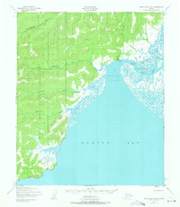
1950 Map of Norton Bay D-5
USGS Topo · Published 1971About this map
The Koyuk settlement serves as the focal point of this 1950s coastal study, situated where the Koyuk River empties into the Koyuk Inlet. This portion of the Seward Peninsula is dominated by the extensive Norton Bay Native Reservation, which encompasses a complex network of waterways including the Mukluktulik River, Miniatulik River, and Kuiuktulik River. These rivers drain the high ground west of Norton Bay, creating a landscape of braided channels and tidal flats.
Find a feature on this map
11 named features on this map. Tap any name to fly to it.
Don’t see what you’re looking for? This feature index may not catch every label — zoom into the map to look around manually.
Map Details
Editions of this 1950 Norton Bay D-5 Map
3 editions found
Other maps of this area

1948 · Norton Bay
USGS Topo · 1:250,000

1950 · Norton Bay D-6
USGS Topo · 1:63,360

1950 · Norton Bay D-5
USGS Topo · 1:63,360

1950 · Norton Bay C-6
USGS Topo · 1:63,360

1950 · Candle A-6
USGS Topo · 1:63,360

1950 · Candle A-5
USGS Topo · 1:63,360

1950 · Norton Bay D-4
USGS Topo · 1:63,360

1950 · Norton Bay C-5
USGS Topo · 1:63,360

1950 · Norton Bay C-4
USGS Topo · 1:63,360

1951 · Candle
USGS Topo · 1:250,000