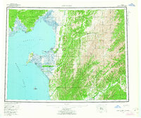
1955 Map of Norton Bay
USGS Topo · Published 1963About this map
Norton Bay Native Reservation and the Reindeer Reservation dominate the western coastal stretch of this mid-century Alaskan survey. The landscape is defined by the complex drainage systems of the Koyuk River, Inglutalik River, and Unalakleet River, which feed into the cold waters of Norton Sound. Evidence of the region's historical logistics is found in the scattering of remote outposts, such as Isaac Roadhouse and Old Woman Cabin, which served as critical transit points along overland routes.
Find a feature on this map
50 named features on this map. Tap any name to fly to it.
Don’t see what you’re looking for? This feature index may not catch every label — zoom into the map to look around manually.
Map Details
Editions of this 1955 Norton Bay Map
4 editions found

Other maps of this area

1945 · Nulato
USGS Topo · 1:250,000

1948 · Norton Bay
USGS Topo · 1:250,000

1950 · Bendeleben A-1
USGS Topo · 1:63,360

1950 · Norton Bay D-6
USGS Topo · 1:63,360

1950 · Bendeleben
USGS Topo · 1:250,000

1950 · Norton Bay B-5
USGS Topo · 1:63,360

1950 · Norton Bay D-5
USGS Topo · 1:63,360

1950 · Solomon C-1
USGS Topo · 1:63,360

1950 · Norton Bay B-4
USGS Topo · 1:63,360

1950 · Norton Bay C-6
USGS Topo · 1:63,360