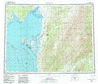
1955 Map of Norton Bay
USGS Topo · Published 1984About this map
The coastal convergence of the Norton Bay and Norton Sound defines this mid-century landscape, a region where marine geography meets the interior Alaskan wilderness. Remote outposts such as Isaacs Roadhouse and the settlement of Shaktolik anchor the coastline near Cape Denbigh, while the interior is marked by historic transit corridors like the Iditarod Trail and Kaltag Trail. These routes follow the natural drainages of the Shaktoolik River and Unalakleet River, tracing paths used for generations before modern aviation reached the Landing Strip at the base of Christmas Mountain. In the eastern mountains, Mount Itliaruk and Debauch Mountain overlook the complex river systems that feed the bay, while solitary landmarks like the Old Woman Cabin on the Portage Trail provide evidence of the era's seasonal trapping and travel patterns.
Find a feature on this map
58 named features on this map. Tap any name to fly to it.
Don’t see what you’re looking for? This feature index may not catch every label — zoom into the map to look around manually.
Map Details
Editions of this 1955 Norton Bay Map
4 editions found

Other maps of this area

1945 · Nulato
USGS Topo · 1:250,000

1948 · Norton Bay
USGS Topo · 1:250,000

1950 · Bendeleben A-1
USGS Topo · 1:63,360

1950 · Norton Bay D-6
USGS Topo · 1:63,360

1950 · Bendeleben
USGS Topo · 1:250,000

1950 · Norton Bay B-5
USGS Topo · 1:63,360

1950 · Norton Bay D-5
USGS Topo · 1:63,360

1950 · Solomon C-1
USGS Topo · 1:63,360

1950 · Norton Bay B-4
USGS Topo · 1:63,360

1950 · Norton Bay C-6
USGS Topo · 1:63,360