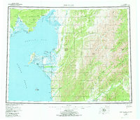
1955 Map of Norton Bay
USGS Topo · Published 1973About this map
The Koyuk Inlet and the expansive waters of Norton Bay anchor this mid-century coastal survey, illustrating a landscape defined by seasonal transit and indigenous territory. Significant land tracts are designated as the Native Reservation and Reindeer Reservation, the latter occupying the prominent peninsula ending at Cape Denbigh. Small outposts like Isaac's Roadhouse and Shaktoolik dot the coastline, while the interior is accessible only via a network of routes including the Kaltag Tenmile Trail and various named portages.
Find a feature on this map
103 named features on this map. Tap any name to fly to it.
Don’t see what you’re looking for? This feature index may not catch every label — zoom into the map to look around manually.
Map Details
Editions of this 1955 Norton Bay Map
4 editions found

Other maps of this area

1945 · Nulato
USGS Topo · 1:250,000

1948 · Norton Bay
USGS Topo · 1:250,000

1950 · Bendeleben A-1
USGS Topo · 1:63,360

1950 · Norton Bay D-6
USGS Topo · 1:63,360

1950 · Bendeleben
USGS Topo · 1:250,000

1950 · Norton Bay B-5
USGS Topo · 1:63,360

1950 · Norton Bay D-5
USGS Topo · 1:63,360

1950 · Solomon C-1
USGS Topo · 1:63,360

1950 · Norton Bay B-4
USGS Topo · 1:63,360

1950 · Norton Bay C-6
USGS Topo · 1:63,360