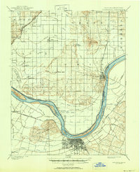
1901 Map of Owensboro
USGS Topo · Published 1950About this map
Owensboro and the winding course of the Ohio River anchor this turn-of-the-century landscape, illustrating the critical river-to-rail connections of the region. The map captures a period when the riverbank was dotted with landings and islands such as Little Hurricane Island and Yellow Bank Island, before modern navigational changes altered the shoreline. On the Indiana side, the southern terminus of the Southern R. R. Rockport Branch meets the water at Rockport, while smaller settlements like Patronville and Eureka are linked by a complex network of drainage ditches, including the Hooppole Ditch and Rose Pond Ditch.
Find a feature on this map
60 named features on this map. Tap any name to fly to it.
Don’t see what you’re looking for? This feature index may not catch every label — zoom into the map to look around manually.
Map Details
Editions of this 1901 Owensboro Map
5 editions found
Other maps of this area

1900 · St Meinrad
USGS Topo · 1:62,500

1900 · De Gonia Springs
USGS Topo · 1:62,500

1901 · Owensboro
USGS Topo · 1:62,500

1902 · Ditney
USGS Topo · 1:125,000

1902 · Degonia Springs
USGS Topo · 1:62,500

1902 · Boonville
USGS Topo · 1:62,500

1903 · St. Meinrad
USGS Topo · 1:62,500

1903 · Tell City
USGS Topo · 1:62,500

1905 · Newburg
USGS Topo · 1:62,500

1906 · Sutherland
USGS Topo · 1:62,500