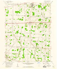
1958 Map of Pataskala
USGS Topo · Published 1959About this map
Pataskala and Pickerington anchor this late-1950s landscape, illustrating a period of mid-century growth along the rural-suburban fringe of central Ohio. The map captures a complex network of transportation and infrastructure, including the Baltimore and Ohio and Pennsylvania railroads running through the northern sector, while the New York Central crosses the southwest. A significant corridor of the National Road bisects the area, passing through Wagram and Etna.
Find a feature on this map
42 named features on this map. Tap any name to fly to it.
Don’t see what you’re looking for? This feature index may not catch every label — zoom into the map to look around manually.
Map Details
Editions of this 1958 Pataskala Map
4 editions found
Other maps of this area

1902 · Westerville
USGS Topo · 1:62,500

1904 · Westerville
USGS Topo · 1:62,500

1907 · Thurston
USGS Topo · 1:62,500

1908 · Granville
USGS Topo · 1:62,500

1909 · Thurston
USGS Topo · 1:62,500

1910 · Granville
USGS Topo · 1:62,500

1925 · East Columbus
USGS Topo · 1:62,500

1943 · East Columbus
USGS Topo · 1:62,500

1947 · Columbus
USGS Topo · 1:250,000

1950 · Marion
USGS Topo · 1:250,000