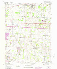
1958 Map of Pataskala
USGS Topo · Published 1985About this map
The South Fork Licking River drainage defines the agricultural and transit corridors of this Licking County and Fairfield County landscape. Early surveying patterns remain highly visible through the Refugee Tract Base Line and Base Line Road, which mark the historical land divisions of the Refugee Tract. The transport network is anchored by the Conrail and Baltimore and Ohio railroads, supporting established villages such as Pataskala and Pickerington.
Find a feature on this map
30 named features on this map. Tap any name to fly to it.
Don’t see what you’re looking for? This feature index may not catch every label — zoom into the map to look around manually.
Map Details
Editions of this 1958 Pataskala Map
4 editions found
Other maps of this area

1902 · Westerville
USGS Topo · 1:62,500

1904 · Westerville
USGS Topo · 1:62,500

1907 · Thurston
USGS Topo · 1:62,500

1908 · Granville
USGS Topo · 1:62,500

1909 · Thurston
USGS Topo · 1:62,500

1910 · Granville
USGS Topo · 1:62,500

1925 · East Columbus
USGS Topo · 1:62,500

1943 · East Columbus
USGS Topo · 1:62,500

1947 · Columbus
USGS Topo · 1:250,000

1950 · Marion
USGS Topo · 1:250,000