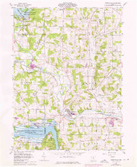
1961 Map of Perrysville
USGS Topo · Published 1976About this map
Penn Central rail lines and the winding course of the Black Fork Mohican River anchor this landscape during a period of infrastructure expansion in central Ohio. The village of Perrysville sits at the heart of the sheet, surrounded by several extensive Gas Fields that underscore the region's energy extraction history. To the south and northwest, the Muskingum Watershed Conservancy District manages the large recreational waters of Pleasant Hill Lake and Charles Mill Lake.
Find a feature on this map
52 named features on this map. Tap any name to fly to it.
Don’t see what you’re looking for? This feature index may not catch every label — zoom into the map to look around manually.
Map Details
Editions of this 1961 Perrysville Map
3 editions found
Other maps of this area

1906 · West Salem
USGS Topo · 1:62,500

1908 · Ashland
USGS Topo · 1:62,500

1908 · West Salem
USGS Topo · 1:62,500

1912 · Loudonville
USGS Topo · 1:62,500

1912 · Perrysville
USGS Topo · 1:62,500

1914 · Loudonville
USGS Topo · 1:62,500

1915 · Perrysville
USGS Topo · 1:62,500

1943 · Loudonville
USGS Topo · 1:62,500

1944 · Perrysville
USGS Topo · 1:62,500

1950 · Marion
USGS Topo · 1:250,000
Featured Places
- Perrysville, OH
- Mifflin Township, OH
- Green Township, OH
- Yacht Point Cottage Area, OH
- Monroe Township, OH