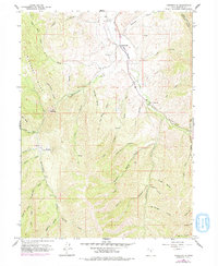
1961 Map of Porterville
USGS Topo · Published 1978About this map
Porterville sits at the northern edge of this high-elevation terrain, where the East Canyon Creek valley opens into the surrounding mountains of Morgan County. The settlement pattern is defined by the water, with the Richville Diversion Dam regulating local flows and the Porterville Cem marking the historic community center. Topography dominates the landscape, characterized by numerous steep drainages such as Hardscrabble Creek, Cottonwood Canyon, and Adams Hollow that feed into the larger creek systems. Historical land use is visible through several pack routes, including the Arthurs Fork Trail and Pine Canyon Trail, which likely served as early mountain access points before modern development. Notable landmarks like Whites Crossing and The Narrows indicate specific points of geographic constraint that shaped the local travel and irrigation infrastructure of the mid-20th century.
Find a feature on this map
41 named features on this map. Tap any name to fly to it.
Don’t see what you’re looking for? This feature index may not catch every label — zoom into the map to look around manually.
Map Details
Editions of this 1961 Porterville Map
3 editions found
Other maps of this area

1885 · Salt Lake
USGS Topo · 1:250,000

1925 · Ft. Douglas
USGS Topo · 1:125,000

1928 · Ft. Douglas
USGS Topo · 1:125,000

1950 · Fort Douglas
USGS Topo · 1:24,000

1951 · Fort Douglas
USGS Topo · 1:24,000

1952 · Bountiful Peak
USGS Topo · 1:24,000

1954 · Salt Lake City
USGS Topo · 1:250,000

1954 · Ogden
USGS Topo · 1:250,000

1955 · Peterson
USGS Topo · 1:24,000

1958 · Ogden
USGS Topo · 1:250,000