
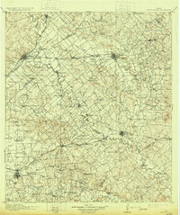
1911 Map of San Marcos
USGS Topo · Published 1911About this map
San Marcos and Lockhart serve as the primary hubs in this early 20th-century landscape, which is densely patterned with rural institutions. The 1911 topography reveals a sophisticated network of country education and worship, featuring dozens of named sites like Rogers Ranch School, Clark Chapel, and Smith Church. The region's economy and movement are defined by the convergence of major rail lines, including the Southern Pacific System and the International and Great Northern RR, which bridge the gap between the San Marcos River and the Guadalupe River.
Find a feature on this map
104 named features on this map. Tap any name to fly to it.
Don’t see what you’re looking for? This feature index may not catch every label — zoom into the map to look around manually.
Map Details
Editions of this 1911 San Marcos Map
2 editions found
Other maps of this area

1885 · Bastrop
USGS Topo · 1:125,000

1887 · Blanco
USGS Topo · 1:125,000

1893 · Bastrop
USGS Topo · 1:125,000

1894 · Blanco
USGS Topo · 1:125,000

1896 · Austin
USGS Topo · 1:125,000

1897 · Austin
USGS Topo · 1:125,000

1901 · Flatonia
USGS Topo · 1:125,000

1904 · Bastrop
USGS Topo · 1:125,000

1910 · Austin
USGS Topo · 1:125,000

1919 · San Marcos
USGS Topo · 1:125,000