
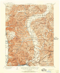
1911 Map of Sciotoville
USGS Topo · Published 1952About this map
Sciotoville and the industrial riverfront at New Boston anchor this landscape along the Ohio River before the heavy modernization of the mid-20th century. The interior is a complex network of narrow hollows and ridges, such as Strauss Ridge and Niner Hill, where small settlements like Minford and Lucasville emerged at vital crossroads. The industrial character of the era is evident in the numerous railroad sidings and stops, including Germany Siding, Wheelers Siding, and Edmunds Switch, which served the local economy of timber and clay.
Find a feature on this map
154 named features on this map. Tap any name to fly to it.
Don’t see what you’re looking for? This feature index may not catch every label — zoom into the map to look around manually.
Map Details
Editions of this 1911 Sciotoville Map
2 editions found
Other maps of this area

1898 · Ironton
USGS Topo · 1:62,500

1900 · Ironton
USGS Topo · 1:62,500

1906 · Waverly
USGS Topo · 1:62,500

1908 · Waverly
USGS Topo · 1:62,500

1912 · Oak Hill
USGS Topo · 1:62,500

1913 · Sciotoville
USGS Topo · 1:62,500

1913 · Jackson
USGS Topo · 1:62,500

1915 · Garrison
USGS Topo · 1:62,500

1915 · Otway
USGS Topo · 1:62,500

1915 · Piketon
USGS Topo · 1:62,500