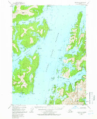
1950 Map of Seward B-3
USGS Topo · Published 1966About this map
Prince William Sound's intricate shoreline and deep-water passages are documented here during the mid-twentieth century, focusing on the massive presence of Knight Island and the western reaches of the Chugach National Forest. The native village of Chenega is a focal point of this coastal landscape, situated on its eponymous island near Chenega Cove and a small Cem. The map reveals a specialized maritime economy, from the activity at Port Audrey on the eastern edge to the Cannery (Abnd) located within the protected waters of Drier Bay. Navigational features like the appropriately named Dangerous Passage and Knight Island Passage surround rugged peaks like Eshamy Peak, illustrating the reliance on waterborne travel for connecting isolated outposts and industrial sites like Snug Harbor.
Find a feature on this map
58 named features on this map. Tap any name to fly to it.
Don’t see what you’re looking for? This feature index may not catch every label — zoom into the map to look around manually.
Map Details
Editions of this 1950 Seward B-3 Map
3 editions found
Other maps of this area

1950 · Seward B-3
USGS Topo · 1:63,360

1951 · Seward
USGS Topo · 1:250,000

1951 · Seward A-2
USGS Topo · 1:63,360

1951 · Seward B-4
USGS Topo · 1:63,360

1951 · Seward A-3
USGS Topo · 1:63,360

1951 · Seward A-4
USGS Topo · 1:63,360

1951 · Seward B-2
USGS Topo · 1:63,360

1951 · Seward C-4
USGS Topo · 1:63,360

1951 · Seward C-3
USGS Topo · 1:63,360

1951 · Seward C-2
USGS Topo · 1:63,360