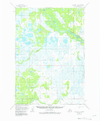
1954 Map of Sleetmute C-2
USGS Topo · Published 1981About this map
The Stony River meanders through a landscape of marsh and tundra in this 1950s survey of the Bethel region. The terrain is defined by a complex network of waterways, where several smaller streams such as Muskrat Creek, Muskeg Creek, and Basket Creek drain into the wider river system. A notable human landmark in this wilderness is the Winter Trail, which provides a seasonal route across the wetlands, crossing over Winter Trail Creek. Surveyors from the Department of the Interior established a fixed reference point at VABM Stony 208, one of the few high-ground markers in a territory largely comprised of unsurveyed land lines. This map captures the area just before the mid-century's minor revisions, documenting the hydraulic patterns of Elutuli Creek and the surrounding basin when movement through the interior relied heavily on these established seasonal trails.
Find a feature on this map
8 named features on this map. Tap any name to fly to it.
Don’t see what you’re looking for? This feature index may not catch every label — zoom into the map to look around manually.
Map Details
Editions of this 1954 Sleetmute C-2 Map
3 editions found
Other maps of this area

1950 · Sleetmute
USGS Topo · 1:250,000

1954 · Sleetmute D-1
USGS Topo · 1:63,360

1954 · Sleetmute D-3
USGS Topo · 1:63,360

1954 · Sleetmute C-2
USGS Topo · 1:63,360

1954 · Sleetmute C-1
USGS Topo · 1:63,360

1954 · Sleetmute D-2
USGS Topo · 1:63,360

1954 · Sleetmute C-3
USGS Topo · 1:63,360

1954 · Sleetmute
USGS Topo · 1:250,000

1954 · Sleetmute B-2
USGS Topo · 1:63,360

1954 · Sleetmute B-3
USGS Topo · 1:63,360