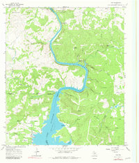
1967 Map of Tow
USGS Topo · Published 1981About this map
The settlement of Tow sits along the western shoreline of Lake Buchanan in this mid-1960s landscape where Llano, Burnet, and San Saba counties meet. The map reveals the dramatic transition from the open waters of the lake to the winding course of the Colorado River as it snakes through narrow valleys marked by Chism Bluff and Barnes Mountain. This 1967 survey highlights the local geography before major modern development, documenting family and historical landmarks such as Tow Cem, Morgan Springs, and the Tanyard Crossing (Historic). The rugged topography is defined by numerous drainage systems like Buzzards Roost Creek and Niter Creek feeding into the river valley, while higher elevations are marked by the Ellenburger Hills and Indian Mountain. This era shows a rural Texas economy still tied to the land, evidenced by small homesteads like Wolf Cabin and localized industrial activity at a Gravel Pit.
Find a feature on this map
46 named features on this map. Tap any name to fly to it.
Don’t see what you’re looking for? This feature index may not catch every label — zoom into the map to look around manually.
Map Details
Editions of this 1967 Tow Map
Other maps of this area

1885 · San Saba
USGS Topo · 1:125,000

1887 · Llano
USGS Topo · 1:125,000

1887 · Lampasas
USGS Topo · 1:125,000

1887 · Burnet
USGS Topo · 1:125,000

1893 · Burnet
USGS Topo · 1:125,000

1894 · Lampasas
USGS Topo · 1:125,000

1894 · San Saba
USGS Topo · 1:125,000

1894 · Llano
USGS Topo · 1:125,000

1903 · Burnet
USGS Topo · 1:125,000

1904 · Llano
USGS Topo · 1:125,000