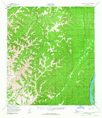
1952 Map of Unalakleet C-2
USGS Topo · Published 1965About this map
The Yukon River dominates the eastern edge of this mid-century survey, its wide channel punctuated by Eagle Island. This remote interior landscape is defined by the winding course of the Old Woman River, which snakes through the western portion of the quadrangle. Smaller tributaries like Bear Creek and Jenson Creek drain the surrounding uplands, feeding the larger river systems that have historically dictated travel and subsistence in this part of Alaska. While much of the terrain appears undeveloped in the early 1950s, a lone Trail is indicated, suggesting established routes of movement across the bush between the river valleys and the interior heights.
Find a feature on this map
6 named features on this map. Tap any name to fly to it.
Don’t see what you’re looking for? This feature index may not catch every label — zoom into the map to look around manually.
Map Details
Editions of this 1952 Unalakleet C-2 Map
4 editions found
Other maps of this area

1950 · Unalakleet D-3
USGS Topo · 1:63,360

1951 · Unalakleet
USGS Topo · 1:250,000

1952 · Unalakleet C-2
USGS Topo · 1:63,360

1952 · Unalakleet D-2
USGS Topo · 1:63,360

1952 · Unalakleet C-3
USGS Topo · 1:63,360

1952 · Unalakleet B-3
USGS Topo · 1:63,360

1952 · Unalakleet C-1
USGS Topo · 1:63,360

1952 · Unalakleet B-2
USGS Topo · 1:63,360

1952 · Unalakleet B-1
USGS Topo · 1:63,360

1952 · Unalakleet D-1
USGS Topo · 1:63,360