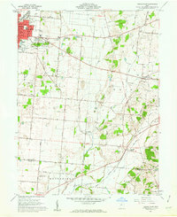
1961 Map of Urbana East
USGS Topo · Published 1962About this map
Urbana serves as the primary hub of this landscape, its western edge defined by the Erie Lackawanna and Pennsylvania railroad corridors. The map records a complex of water features northeast of the city center, including First Price Pond, Second Price Pond, and Third Price Pond, likely tied to the area's early industrial or recreational history. Significant land use is dedicated to civic and community life, from the Hospital and Fairgrounds in the urban core to the expansive Oakdale Cemetery.
Find a feature on this map
57 named features on this map. Tap any name to fly to it.
Don’t see what you’re looking for? This feature index may not catch every label — zoom into the map to look around manually.
Map Details
Editions of this 1961 Urbana East Map
4 editions found
Other maps of this area

1904 · Springfield
USGS Topo · 1:62,500

1906 · Springfield
USGS Topo · 1:62,500

1907 · South Charleston
USGS Topo · 1:62,500

1914 · St. Paris
USGS Topo · 1:62,500

1914 · Mechanicsburg
USGS Topo · 1:62,500

1916 · Mechanicsburg
USGS Topo · 1:62,500

1916 · St. Paris
USGS Topo · 1:62,500

1944 · Mechanicsburg
USGS Topo · 1:62,500

1944 · St. Paris
USGS Topo · 1:62,500

1947 · Columbus
USGS Topo · 1:250,000