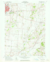
1961 Map of Urbana East
USGS Topo · Published 1972About this map
Urbana serves as the primary urban center for this 1961 survey, where the Erie Lackawanna and Pennsylvania railroads intersect near Factory Pond. The landscape east of the city is defined by a series of water bodies including First Price Pond, Second Price Pond, and Third Price Pond, illustrating the importance of local water resources to the regional economy. Further east, the village of Mutual and the transit point at Catawba Station highlight the rural settlement patterns along the New York Central rail line.
Find a feature on this map
64 named features on this map. Tap any name to fly to it.
Don’t see what you’re looking for? This feature index may not catch every label — zoom into the map to look around manually.
Map Details
Editions of this 1961 Urbana East Map
4 editions found
Other maps of this area

1904 · Springfield
USGS Topo · 1:62,500

1906 · Springfield
USGS Topo · 1:62,500

1907 · South Charleston
USGS Topo · 1:62,500

1914 · St. Paris
USGS Topo · 1:62,500

1914 · Mechanicsburg
USGS Topo · 1:62,500

1916 · Mechanicsburg
USGS Topo · 1:62,500

1916 · St. Paris
USGS Topo · 1:62,500

1944 · Mechanicsburg
USGS Topo · 1:62,500

1944 · St. Paris
USGS Topo · 1:62,500

1947 · Columbus
USGS Topo · 1:250,000